 |
| Looking towards Edale Valley. The Great Ridge can be seen middle left of the photograph and Kinder Scout beyond. |
After the sunrise on Mam Tor (as seen in the previous post), we had a days walking ahead of us. After my wild camp near Win Hill and walk across The Great Ridge a few months ago, I had said that I would revisit the same hills for a days walking with Phil and Matt, my regular day trip companions. Matt had suffered a bit of a knock at football the weekend before and so sat this walk out, but Phil and I enjoyed a great day nonetheless...
The day started very well. The sunrise was stunning, and I can't think of anything more encouraging for a days walking than the morning sun breaking through a barrier of dense, murky clouds. The morning was quite a murky one. Cloud hung lower than the UK's international credit rating, threatening to mask the approaching sunrise. Looking in all directions, all of the highest hills in the area still had a little covering of snow accompanied by invisible peaks behind the clag.
 |
| The cloud eventually started to break, looking over the Vale of Edale to the Kinder Plateau. |
As time went on, we began to see clearer skies over Kinder Scout, and the same began to happen down in the neighbouring Hope Valley too. As the sun broke through, the light was glorious. It reminded me so much of my first wild camp morning. There were stronger feelings than just reminiscence though. The contrast between when we arrived at the top of Mam Tor, to the moments that the sun appeared through that bank of cloud was such a juxtaposition; that it was almost as if we were seeing the sun after a long Arctic winter in total darkness. It was such a fulfilling experience.
 |
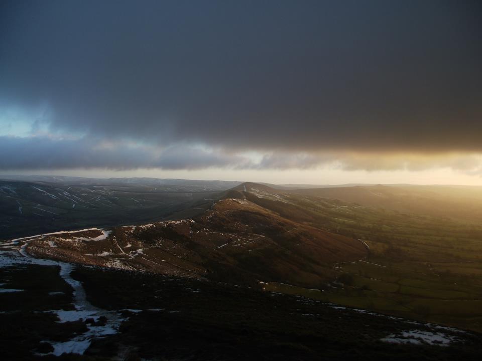
| The sun cast an inferno of light over the Hope Valley. |
I decided to take the opportunity of the morning to try make a timelapse video of the sunrise. Taking a series of photographs and combining them into 'video' at 25fps was the method. Doing this requires a lot of photographs, and so; I only made a couple of seconds of 'video' which I will post at the bottom of this entry. One of the most entertaining sights of the morning, was the view straight down the Great Ridge; with Edale Valley on the left and the Hope Valley on the right. The ridge made for a great division of the morning light and left the Hope Valley cascaded in light, while Edale Valley was still in relative darkness. It made me wish that I'd taken pictures from that view in order to make another timelapse video, to show the advance of the morning sun.
 |
| The Great Ridge spliced the light in an impressive way. |
As can be seen from the pictures, there were still odd bits of snow left around from previous weeks, and throughout the day there was varying amounts upon the highest ground in the area. It made walking difficult at times, and on one occasion it became quite painful. I ended up putting my foot through some snow, straight onto a wet rock which I then slipped on and landed flat on my face, bashing my knee on a rock in the process. Definitely hurt. I broke one strap of my rucksack too, somehow.
 |
| Deep snow on the side of Mam Tor. |
After the sun was firmly placed above the horizon, we decided to descend to the foot of Mam Tor in order to have a look at the old broken road. During the time we had been on the summit, we looked down upon it with curiosity. We knew about it of course, but hadn't taken the time to study it first hand. This section of the road was originally laid in 1819 on the landslip of Mam Tor's southern side. As a result of further movement, major road
works were needed regularly between 1912 and 1974. Afterwards, more road
works were carried out, when persistant wet weather led to further
landslips. Finally, the Mam Tor section of the road was closed off in
1979. Seeing the road up close reminded me how powerful and unpredictable nature, and life; can be. No matter how much we deface the natural landscape with horrible grey, it can and will always kick back eventually.
 |
| The broken section of the A625, under Mam Tor. |
After spending some time on the broken road, we drove east to Hope. The original plan was to walk up, and back down, Win Hill before grabbing some breakfast; but the early start had certainly taken its toll. After a quick hunt around, we parked up in the pay and display car park with the intention of leaving the car there for the day. After realising that it was quite pricey, we drove a little further and came across The Old Hall, which had its own sizeable car park. Usually, in the Peak District, you will find that business owners are generally really friendly and willing to help. So we thought it might be worth asking if we could pay a couple of pounds to leave the car there for the day. Noticing that they had a tea room adjoining the main building, we headed inside for some breakfast. Lovely breakfast it was too! Very reasonably priced, and after a chat about hill walking with the lady working that morning, we wangled permission to leave the car there all day (seeing as though we had ordered breakfast).
I took the opportunity to use the View Ranger app on my smartphone again for this walk. But again, I didn't use it for navigational purposes - only to map our route. Once again, the battery began to tire and I cut the mapping short. The map of the walk can be seen below:
We set off up Edale Road to take up the path that passes Fullwood Stile Farm and meets the Roman road, up and over Hope Brink. On the way up, we followed the path all the way up to the guidepost, doubled back on ourselves and then on towards Win Hill. The view from the guidepost to the west is probably my favourite that I have experienced thus far. Looking down into the Vale of Edale, you can see right to the western side and Brown Knoll etc. The Kinder Plateau looks tall and vast on your right to the north, and the Great Ridge sitting proud on your left to the south. I still find it hard to believe that I used to pass through the valley on the train, and I never realised just what was a stone's throw away. The view also gives you a taste of just how big and impressive the Peak District is.
 |
| One of my favourite views in the Peak District. Especially when there is still a light covering of snow. |
We pressed on towards Win Hill, and I was glad that we hadn't taken the route up from Yorkshire Bridge after the filling breakfast we'd had. Also, knowing that Lose Hill would likely challenge Phil - I thought it best to save that particular route up Win Hill for another day. That said, last time I took that route I did have a 65ltr rucksack on my back. We began to see more and more outdoorsy people as we got closer, plenty of fell runners which didn't come as a big surprise considering the good clear weather.
 |
| Approaching Win Hill, with Ladybower Reservoir in the distance. |
When we finally stood on Win Hill pike, the wind was horrendous. It was very strange because, below the pike there had been no wind at all. We stayed for quite a while to take in the view. Again, I think that the view from here is probably one of my favourite in all the Peak District. It was the first time that Phil had seen Ladybower Reservoir since we started walking. The sky was alot clearer than the last time I had been on Win Hill, and it certainly improved the view for me. It just seemed to make it much more pleasant, being able to see further around and the reflection of the light on Ladybower.
The other aspect of the view that impresses me is looking across in particular to Edale Valley/ The Great Ridge/ Kinder Scout. It just looks so bloody vast and huge! Despite the fact that it isn't really a mountain range in comparison to the Scaffells for example, it still feels like it is as tall and rugged and that it rightfully demands as much respect.
 |
| The impressive, generally north westward view from Win Hill pike. |
After stopping for a drink and something quick to eat on Win Hill pike, we got on our way back down the Roman road towards Hope. On the way down, we looked across to Lose Hill and the climb doesn't really look too bad. Phil definitely didn't think the same on the way up though. It's not to say that either of us are unfit by any means, but we're still breaking ourselves into hill walking. Having ventured out myself on numerous occasions, I didn't find it too tough. But then I remembered the first time that I had tackled the path up the south-east side. Just as that first time, curiously enough - there was not a whisper of wind on the way up Lose Hill, or even when we reached the summit. While sat looking down into the valley, a familiar fell runner approached from the other end of the Great Ridge. He quickly reached us, giving a friendly nod. It was the chap that had passed us on Win Hill as we reached the top. I could not believe just how much ground he must have covered, so I asked him which route he had taken. Straight down the Roman road from Win Hill, up to Crookstone Out Moor, along the plateau to Ringing Roger, down The Nab, across Edale and up Hollins Cross then along to Lose Hill. Very impressive. I know that I couldn't do it.
 |
| Lose Hill summit, with the sun shining down on Mam Tor in the distance. |
We cracked on and headed west across the Great Ridge, over Back Tor, Hollins Cross and then back to Mam Tor where we had started the day. The snow was probably deepest still on the Great Ridge, and it made it slightly more difficult than it would have been otherwise, of course. It made for some light-heartedness as well though, with every other step one of us ended up thigh deep in the stuff. It reminded me quite strongly that I should probably invest in some gaiters. Cold snow around you ankles and leaking down into the heel of your boot doesn't feel comfortable!
 |
| Sometimes your foot would stay on top of the snow, other time it would plunge a couple of feet under. |
After we had gotten to Mam Tor and stopped for a short rest, we decided to head back into Castleton and possibly to Peveril Castle. We always enjoy abit of historical context, as you can tell from some of my other entries. Phil had read about the castle in great depth, and I had done a little light reading in a book that I had got for Christmas. In the end, the combination of a 5.00am start, and the respectable distance we had walked - we decided to knock that idea on the head and save it for a time when we could get round some of the caves as well as the castle in one day. We were disappointed, but relieved at the same time, as we had both long since ran out of food and had begun to feel very hungry.
 |
| Peveril Castle. |


No comments:
Post a Comment